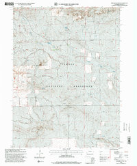
1997 Map of Pawnee Buttes
USGS Topo · Published 2000About this map
Pawnee National Grassland dominates this high plains landscape in Weld County, Colorado, where the prominent twin landforms of the Pawnee Buttes rise above the surrounding prairie. This 1997 revision by the Forest Service captures an arid region defined by its vital water sources and energy extraction. A network of springs, including Demoss Spring, Reisburg Spring, and Elizabeth Spring, suggests the locations of essential water stops in an otherwise dry environment.
Find a feature on this map
16 named features on this map. Tap any name to fly to it.
Don’t see what you’re looking for? This feature index may not catch every label — zoom into the map to look around manually.
Map Details
Editions of this 1997 Pawnee Buttes Map
This is the sole edition of this map. No revisions or reprints were ever made.
Other maps of this area

1954 · Sterling
USGS Topo · 1:250,000

1954 · Greeley
USGS Topo · 1:250,000

1957 · Greeley
USGS Topo · 1:250,000

1958 · Greeley
USGS Topo · 1:250,000

1958 · Sterling
USGS Topo · 1:250,000

1961 · Greeley
USGS Topo · 1:250,000

1964 · Greeley
USGS Topo · 1:250,000

1965 · Greeley
USGS Topo · 1:250,000
1972 · Keota
USGS Topo · 1:24,000
1972 · Grover SE
USGS Topo · 1:24,000