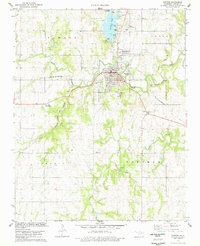
1978 Map of Pawnee
USGS Topo · Published 1978About this map
Pawnee serves as the central hub of this late 1970s survey, situated at the junction of the St Louis - San Francisco and the Atchison Topeka and Santa Fe railroads. The town's historical identity is deeply connected to the Pawnee Bill Museum State Park and the nearby Old Town Trading Post, reflecting the area's heritage. To the north, Pawnee Lake is a prominent recreational feature, supported by a Fish Hatchery, Boat Ramp, and Campground.
Find a feature on this map
32 named features on this map. Tap any name to fly to it.
Don’t see what you’re looking for? This feature index may not catch every label — zoom into the map to look around manually.
Map Details
Editions of this 1978 Pawnee Map
This is the sole edition of this map. No revisions or reprints were ever made.
Other maps of this area

1929 · Yale
USGS Topo · 1:62,500

1929 · Ripley
USGS Topo · 1:62,500

1929 · Skedee
USGS Topo · 1:62,500

1930 · Pawnee
USGS Topo · 1:62,500

1931 · Skedee
USGS Topo · 1:62,500

1932 · Yale
USGS Topo · 1:62,500

1932 · Ripley
USGS Topo · 1:62,500

1936 · Pawnee
USGS Topo · 1:62,500

1955 · Enid
USGS Topo · 1:250,000

1958 · Enid
USGS Topo · 1:250,000