1942 Map of Pawtucket
USGS Topo · Published 1942About this map
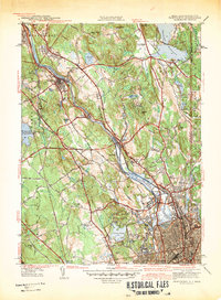
The Blackstone River serves as the industrial and geographic spine of this Rhode Island corridor during the early 1940s, connecting a dense string of mill towns and villages from Woonsocket down to Pawtucket. The map reveals an intricate network of water management, with numerous reservoirs and ponds like Sneech Pond and Valley Falls Pond powering the region's productive capacity. Transport is dominated by the New York New Haven and Hartford RR, which parallels the river and services vital stops such as Lonsdale Sta. Away from the riverbanks, the terrain rises toward landmark heights like Sayles Hill and Beacon Pole Hill, while the Lincoln Woods Reservation provides a significant expanse of protected woodland. Local social history is grounded in specific institutions, including the Cistercian Monastery and a variety of sectarian burial grounds such as St James Cem and the Polish Cem.
Find a feature on this map
85 named features on this map. Tap any name to fly to it.
Don’t see what you’re looking for? This feature index may not catch every label — zoom into the map to look around manually.
Map Details
Editions of this 1942 Pawtucket Map
This is the sole edition of this map. No revisions or reprints were ever made.
Other maps of this area

1886 · Blackstone
USGS Topo · 1:62,500

1887 · Franklin
USGS Topo · 1:62,500

1887 · Providence
USGS Topo · 1:62,500

1889 · Providence
USGS Topo · 1:62,500

1889 · Blackstone
USGS Topo · 1:62,500

1889 · Franklin
USGS Topo · 1:62,500

1889 · Burrillville
USGS Topo · 1:62,500

1893 · Franklin
USGS Topo · 1:62,500

1893 · Blackstone
USGS Topo · 1:62,500

1894 · Burrillville
USGS Topo · 1:62,500