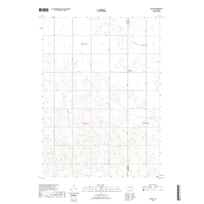
2017 Map of Paxton
USGS Topo · Published 2017About this map
Paxton sits at the junction of Co Hwy 11 and Co Rd 14, serving as a central point for this rural landscape along the boundary of Tripp Co and Gregory Co. The area is defined by a dendritic drainage network, with Buffalo Cr and Lute Cr carving through the prairie terrain. Significant for local history, Saint Johns Catholic Cem is located just outside the settlement, providing a genealogical anchor for the community. The map reveals a strict section-line road grid typical of the Great Plains, featuring routes like 296th St and 331st Ave. Small watercourses including Mastodon Cr and Dry Cr cross the southern and eastern portions of the township, illustrating the natural water resources that shaped early ranching and agricultural development in this part of South Dakota.
Find a feature on this map
30 named features on this map. Tap any name to fly to it.
Don’t see what you’re looking for? This feature index may not catch every label — zoom into the map to look around manually.
Map Details
Editions of this 2017 Paxton Map
This is the sole edition of this map. No revisions or reprints were ever made.
Other maps of this area

1955 · Mitchell
USGS Topo · 1:250,000

1955 · O'Neill
USGS Topo · 1:250,000

1959 · O'Neill
USGS Topo · 1:250,000

1959 · Mitchell
USGS Topo · 1:250,000

1964 · Dallas SW
USGS Topo · 1:24,000

1964 · Mills
USGS Topo · 1:24,000

1964 · Gregory
USGS Topo · 1:24,000

1964 · Dallas
USGS Topo · 1:24,000

1964 · Paxton
USGS Topo · 1:24,000
1964 · Burton
USGS Topo · 1:24,000