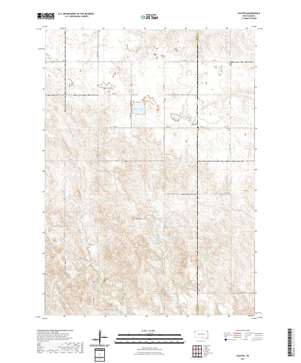
2021 Map of Paxton
USGS Topo · Published 2021About this map
Paxton serves as the central anchor for this corner of the South Dakota prairie, situated along the county line where Tripp and Gregory Counties meet. This agricultural landscape is defined by the winding drainage systems of Buffalo Creek and Lute Creek, which carve distinct patterns across the township sections. The religious and communal heritage of the area is centered at Saint Johns Catholic Church and its accompanying Saint Johns Catholic Cemetery, which provide critical touchpoints for genealogical research in this rural district. To the north, the presence of Lambert Lake adds a significant water feature to the otherwise stream-bisected terrain. The layout of the land follows the rigorous Public Land Survey System, with a grid of local roads like Viaduct Road and County Highway 11 providing access to the isolated farmsteads that characterize this portion of the Great Plains.
Find a feature on this map
35 named features on this map. Tap any name to fly to it.
Don’t see what you’re looking for? This feature index may not catch every label — zoom into the map to look around manually.
Map Details
Editions of this 2021 Paxton Map
This is the sole edition of this map. No revisions or reprints were ever made.
Other maps of this area

1955 · Mitchell
USGS Topo · 1:250,000

1955 · O'Neill
USGS Topo · 1:250,000

1959 · O'Neill
USGS Topo · 1:250,000

1959 · Mitchell
USGS Topo · 1:250,000

1964 · Dallas SW
USGS Topo · 1:24,000

1964 · Mills
USGS Topo · 1:24,000

1964 · Gregory
USGS Topo · 1:24,000

1964 · Dallas
USGS Topo · 1:24,000

1964 · Paxton
USGS Topo · 1:24,000
1964 · Burton
USGS Topo · 1:24,000