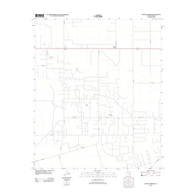
2012 Map of Paynes Corner
USGS Topo · Published 2012About this map
The oil and gas industry defines the landscape of Gaines County at the turn of the decade, as seen in this 2012 study of the West Texas plains. Centered on the crossroads of Paynes Corner, the map reveals an intensive grid of service roads and infrastructure supporting large-scale petroleum extraction. The complex network of county roads, such as Co RD-319 and Co RD-315, provides access to numerous well sites and facilities including the Riley Oil Field, the North Riley Oil Field, and the central Riley Gas Plant. This industrial footprint is typical of the Permian Basin's modern development, where agricultural section lines often merge with the utilitarian geometry of energy production. Regional connectivity is maintained by Ranch Road 1757 and Ranch Road 181, which link this productive corner of the county to the wider Texas road system.
Find a feature on this map
19 named features on this map. Tap any name to fly to it.
Don’t see what you’re looking for? This feature index may not catch every label — zoom into the map to look around manually.
Map Details
Editions of this 2012 Paynes Corner Map
This is the sole edition of this map. No revisions or reprints were ever made.
Other maps of this area

1954 · Hobbs
USGS Topo · 1:250,000

1958 · Hobbs
USGS Topo · 1:250,000

1969 · Seminole SW
USGS Topo · 1:24,000

1970 · Seagraves SW
USGS Topo · 1:24,000

1970 · Seminole
USGS Topo · 1:24,000

1971 · Paynes Corner
USGS Topo · 1:24,000

1971 · Brinson Ranch
USGS Topo · 1:24,000

1971 · Paynes Corner SE
USGS Topo · 1:24,000

1971 · Denver City SW
USGS Topo · 1:24,000
1971 · Paynes Corner NW
USGS Topo · 1:24,000