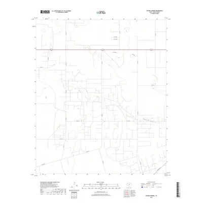
2019 Map of Paynes Corner
USGS Topo · Published 2019About this map
Seminole Draw carves a subtle path through the high plains of West Texas, anchoring this 2019 survey of the area around Paynes Corner. This agricultural and ranching landscape is defined by a dense grid of local infrastructure, including Co RD 308, Co RD 323, and Co RD 319, which provide access to the vast acreage of Gaines County. The map captures the geometric precision of rural development, where state routes like FM 1757 and Ranch Rd 181 intersect with the primary east-west corridor of 62 180. This survey offers genealogists and local historians a contemporary look at land use and road networks, tracing the path of Nadine Rd and other rural byways that sustain the region's agricultural economy.
Find a feature on this map
19 named features on this map. Tap any name to fly to it.
Don’t see what you’re looking for? This feature index may not catch every label — zoom into the map to look around manually.
Map Details
Editions of this 2019 Paynes Corner Map
This is the sole edition of this map. No revisions or reprints were ever made.
Other maps of this area

1954 · Hobbs
USGS Topo · 1:250,000

1958 · Hobbs
USGS Topo · 1:250,000

1969 · Seminole SW
USGS Topo · 1:24,000

1970 · Seagraves SW
USGS Topo · 1:24,000

1970 · Seminole
USGS Topo · 1:24,000

1971 · Paynes Corner
USGS Topo · 1:24,000

1971 · Brinson Ranch
USGS Topo · 1:24,000

1971 · Paynes Corner SE
USGS Topo · 1:24,000

1971 · Denver City SW
USGS Topo · 1:24,000
1971 · Paynes Corner NW
USGS Topo · 1:24,000