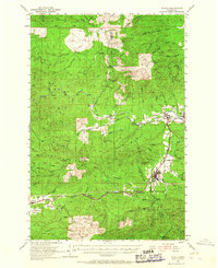
1953 Map of Pe Ell
USGS Topo · Published 1967About this map
The town of Pe Ell serves as a central hub in this mid-century survey of the rugged timberlands where the Pacific Co Lewis Co line divides the landscape. This era reflects a transition in the Pacific Northwest timber and rail industry, evidenced by the presence of the Northern Pacific and the Milwaukee Chicago St Paul and Pacific railroads. While the lumber settlements of Dryad, Doty, and Murnen dot the eastern edge, much of the terrain is defined by steep ridges like Huckleberry Ridge and prominent peaks such as Walville Peak.
Find a feature on this map
72 named features on this map. Tap any name to fly to it.
Don’t see what you’re looking for? This feature index may not catch every label — zoom into the map to look around manually.
Map Details
Editions of this 1953 Pe Ell Map
3 editions found

Other maps of this area

1940 · Montesano
USGS Topo · 1:62,500

1940 · Brookfield
USGS Topo · 1:62,500

1941 · Walville
USGS Topo · 1:62,500

1941 · Meskill
USGS Topo · 1:62,500

1941 · Gate
USGS Topo · 1:62,500

1941 · Skamokawa
USGS Topo · 1:62,500

1941 · Ford
USGS Topo · 1:62,500

1953 · Hoquiam
USGS Topo · 1:250,000

1953 · Ryderwood
USGS Topo · 1:62,500

1953 · Rochester
USGS Topo · 1:62,500