1989 Map of Peabody
USGS Topo · Published 1989About this map
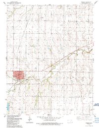
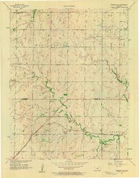
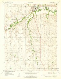
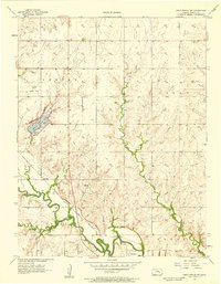
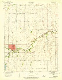
Peabody serves as the primary hub in this portion of Kansas, centered at the confluence of Doyle Creek and Spring Creek. The town's grid is well-defined, featuring a local High Sch, a central Park, and a municipal Sewage Disposal facility. To the north, the small settlement of Slocombe and the Prairie Lawn Cem mark the transition into a landscape heavily influenced by energy extraction. Extensive Oil Field operations are scattered across the northern and eastern sections, particularly within the townships of Catlin, Fairplay, and Summit. The topography is shaped by these winding creek valleys and a network of Pipeline infrastructure, illustrating the dual nature of the region as both a settled agricultural community and an active petroleum production zone.
Find a feature on this map
16 named features on this map. Tap any name to fly to it.
Don’t see what you’re looking for? This feature index may not catch every label — zoom into the map to look around manually.
Map Details
Editions of this 1989 Peabody Map
This is the sole edition of this map. No revisions or reprints were ever made.
Other maps of this area

1889 · Newton
USGS Topo · 1:125,000

1894 · Newton
USGS Topo · 1:125,000

1898 · Cottonwood Falls
USGS Topo · 1:125,000

1955 · Hutchinson
USGS Topo · 1:250,000
1957 · Peabody NW
USGS Topo · 1:24,000
1957 · Florence
USGS Topo · 1:24,000
1957 · Lincolnville SW
USGS Topo · 1:24,000
1957 · Peabody
USGS Topo · 1:24,000
1957 · Elbing
USGS Topo · 1:24,000

1959 · Hutchinson
USGS Topo · 1:250,000