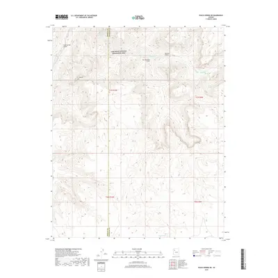
2018 Map of Peach Springs NE
USGS Topo · Published 2018About this map
Lake Mead National Recreation Area encompasses the northern reaches of this high desert terrain, where deep drainage systems carve through the plateau. The landscape is defined by the convergence of several major geological features, notably Peach Springs Canyon and Diamond Canyon. Water sources are sparse but critical in this environment, evidenced by the presence of Metuck Tank in the south and Diamond Spring to the northeast. The boundary between Mohave County and Coconino County bisects the quadrangle, marking a transition in jurisdictional land management across the arid canyons. High points such as the Thumb overlook the winding path of Peach Springs Wash, illustrating the complex erosion patterns that lead toward the Colorado River system. This 2018 survey provides a clear view of the natural topography and established boundaries before modern developments altered these traditional desert routes.
Find a feature on this map
14 named features on this map. Tap any name to fly to it.
Don’t see what you’re looking for? This feature index may not catch every label — zoom into the map to look around manually.
Map Details
Editions of this 2018 Peach Springs NE Map
This is the sole edition of this map. No revisions or reprints were ever made.
Other maps of this area

1886 · Diamond Creek
USGS Topo · 1:250,000

1892 · Diamond Creek
USGS Topo · 1:250,000

1948 · Williams
USGS Topo · 1:250,000

1954 · Williams
USGS Topo · 1:250,000

1956 · Williams
USGS Topo · 1:250,000

1960 · Williams
USGS Topo · 1:250,000

1961 · Williams
USGS Topo · 1:250,000

1967 · Peach Springs
USGS Topo · 1:24,000
1967 · Travertine Rapids
USGS Topo · 1:24,000
1967 · Peach Springs Canyon
USGS Topo · 1:24,000