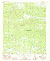
1983 Map of Peanut Mountain
USGS Topo · Published 1984About this map
Peanut Mountain and the surrounding peaks of the Ouachita National Forest define this corner of Scott County, where the topography dictates a scattered settlement pattern. Small communities such as Denton and Blansett occupy the narrow corridors between Brushy Mountain and Henry Mountain, while the southern reaches of the map are drained by the Fourche La Fave River and its major tributaries like Black Fork and Clear Fork. This landscape reflects a late 20th-century view of the region's managed forests and rural outposts, where gravel roads and unimproved trails provide access to family landmarks and cemeteries such as the Cem near Nella. The mapping reveals how local life was centered along these waterways, from the Jones Creek valley to the heights of Piney Mountain, preserving the locations of homes and fords before modern development could obscure the early road network.
Find a feature on this map
34 named features on this map. Tap any name to fly to it.
Don’t see what you’re looking for? This feature index may not catch every label — zoom into the map to look around manually.
Map Details
Editions of this 1983 Peanut Mountain Map
This is the sole edition of this map. No revisions or reprints were ever made.
Other maps of this area

1879 · Poteau Mountain
USGS Topo · 1:62,500

1887 · Poteau Mountain #1
USGS Topo · 1:62,500

1887 · Poteau Mountain #2
USGS Topo · 1:62,500

1890 · Poteau Mountain
USGS Topo · 1:125,000

1899 · Poteau Mountain
USGS Topo · 1:125,000

1939 · Waldron
USGS Topo · 1:62,500

1940 · Waldron
USGS Topo · 1:62,500

1941 · Waldron
USGS Topo · 1:62,500

1949 · Waldron
USGS Topo · 1:62,500

1950 · Mcalester
USGS Topo · 1:250,000