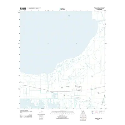
2012 Map of Pecan Island
USGS Topo · Published 2012About this map
White Lake dominates the northern expanse of this coastal Louisiana landscape, where the geography is defined by a series of cheniers—low-lying sandy ridges that rise above the surrounding marsh. The settlement of Pecan Island follows these elevated landforms, creating a linear corridor of habitation and agriculture amidst the wetlands. This 2012 survey illustrates a distinct cultural adaptation to the environment, with infrastructure tightly hugging features like Sweet Bay Ridge, Cane Ridge, and Back Ridge. Local transportation routes, including Front Ridge Rd and Veazey Rd, trace the natural contours of the land, providing access to remote points such as Cypress Point and Fire Island. The map documents the persistent relationship between the residents of Vermilion Parish and the fragile, water-bound terrain of the Gulf Coast.
Find a feature on this map
15 named features on this map. Tap any name to fly to it.
Don’t see what you’re looking for? This feature index may not catch every label — zoom into the map to look around manually.
Map Details
Editions of this 2012 Pecan Island Map
This is the sole edition of this map. No revisions or reprints were ever made.
Other maps of this area

1932 · Constance Bayou NE
USGS Topo · 1:31,680

1932 · Pecan Island SE
USGS Topo · 1:31,680

1932 · Pecan Island SW
USGS Topo · 1:31,680

1932 · Constance Bayou SE
USGS Topo · 1:31,680

1945 · Pecan Island NW
USGS Topo · 1:31,680

1945 · Pecan Island NE
USGS Topo · 1:31,680

1946 · Schooner Bayou SE
USGS Topo · 1:31,680

1946 · Schooner Bayou SW
USGS Topo · 1:31,680

1951 · Pecan Island
USGS Topo · 1:62,500

1953 · Jacks Point Island
USGS Topo · 1:24,000