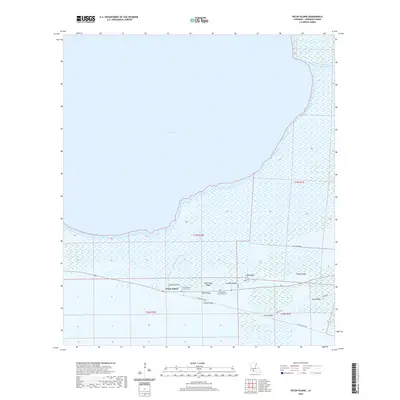
2020 Map of Pecan Island
USGS Topo · Published 2020About this map
Pecan Island emerges from the marsh as a series of distinct ridges and points, serving as a primary corridor for settlement in this coastal stretch of Vermilion Parish. The map reveals how the local geography dictates the layout of the community, with homes and structures concentrated along Front Ridge and Back Ridge. These elevated sections provide a dry footing amidst the surrounding wetlands that stretch toward White Lake to the north.
Find a feature on this map
23 named features on this map. Tap any name to fly to it.
Don’t see what you’re looking for? This feature index may not catch every label — zoom into the map to look around manually.
Map Details
Editions of this 2020 Pecan Island Map
This is the sole edition of this map. No revisions or reprints were ever made.
Other maps of this area

1932 · Constance Bayou NE
USGS Topo · 1:31,680

1932 · Pecan Island SE
USGS Topo · 1:31,680

1932 · Pecan Island SW
USGS Topo · 1:31,680

1932 · Constance Bayou SE
USGS Topo · 1:31,680

1945 · Pecan Island NW
USGS Topo · 1:31,680

1945 · Pecan Island NE
USGS Topo · 1:31,680

1946 · Schooner Bayou SE
USGS Topo · 1:31,680

1946 · Schooner Bayou SW
USGS Topo · 1:31,680

1951 · Pecan Island
USGS Topo · 1:62,500

1953 · Jacks Point Island
USGS Topo · 1:24,000