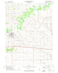
1971 Map of Pecatonica
USGS Topo · Published 1974About this map
The Pecatonica River winds prominently through this northern Illinois landscape, defining the northern half of the region as it flows past the village of Pecatonica. The town is a focal point of infrastructure, featuring Fairground Park, a local sewage disposal plant, and the Pecatonica Airport. To the southeast, the village of Winnebago sits at the edge of the survey, connected by a network of rural routes such as Telegraph Road and Winnebago Road.
Find a feature on this map
41 named features on this map. Tap any name to fly to it.
Don’t see what you’re looking for? This feature index may not catch every label — zoom into the map to look around manually.
Map Details
Editions of this 1971 Pecatonica Map
This is the sole edition of this map. No revisions or reprints were ever made.
Other maps of this area

1917 · Kings
USGS Topo · 1:62,500

1918 · Rockford
USGS Topo · 1:62,500

1918 · Kings
USGS Topo · 1:62,500

1922 · Oregon
USGS Topo · 1:62,500

1924 · Oregon
USGS Topo · 1:62,500

1932 · Pecatonica
USGS Topo · 1:62,500

1936 · Pecatonica
USGS Topo · 1:62,500

1938 · Rockford
USGS Topo · 1:62,500

1954 · Rockford
USGS Topo · 1:250,000

1955 · Rockford
USGS Topo · 1:250,000