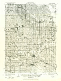
1932 Map of Pecatonica
USGS Topo · Published 1972About this map
The Pecatonica River meanders across this northern Illinois landscape, defining the character of the settlements and transit routes in Stephenson and Winnebago counties. In the early 1930s, the region was a dense network of rural school districts and small villages connected by three major railroads: the Chicago Milwaukee St Paul and Pacific, the Chicago and North Western, and the Illinois Central. The sheer number of educational sites, such as Pleasant View Sch and Farmingdale Sch, speaks to a decentralized rural population before school consolidation. Key river crossings like Farwell Bridge and Trask Bridge were vital for local commerce. Genealogists will find significant value in the location of family-centric landmarks and historic burial grounds, including Pioneer Cem near Rock City and the Irish Grove Ch located northwest of the main river valley.
Find a feature on this map
82 named features on this map. Tap any name to fly to it.
Don’t see what you’re looking for? This feature index may not catch every label — zoom into the map to look around manually.
Map Details
Editions of this 1932 Pecatonica Map
3 editions found

Other maps of this area

1891 · Janesville
USGS Topo · 1:62,500

1893 · Janesville
USGS Topo · 1:62,500

1893 · Brodhead
USGS Topo · 1:62,500

1917 · Kings
USGS Topo · 1:62,500

1918 · Rockford
USGS Topo · 1:62,500

1918 · Kings
USGS Topo · 1:62,500

1920 · Monroe
USGS Topo · 1:62,500

1922 · Monroe
USGS Topo · 1:62,500

1922 · Oregon
USGS Topo · 1:62,500

1924 · Oregon
USGS Topo · 1:62,500