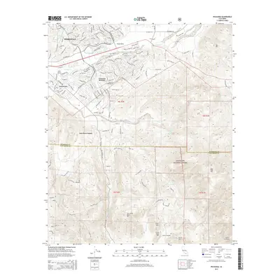
2015 Map of Pechanga
USGS Topo · Published 2015About this map
Temecula and the northern reaches of the Cleveland National Forest define this landscape along the Riverside and San Diego County line. The transition from suburban development in Temecula Ranchos and Wolf Valley to the steep, chaparral-covered slopes of the Peninsular Ranges is immediate. Water management is a central theme, with the San Diego Aqueduct and Second San Diego Aqueduct cutting through the terrain, while Pechanga Cr and Temecula Cr drain the surrounding valleys. High peaks like Agua Tibia Mtn and Tourmaline Queen Mtn overlook the canyons, including Castro Canyon and Marion Canyon. The map details the complex road network from the residential streets of Colina Vista to remote routes such as the Magee Truck Tr and Lost Horizon Dr.
Find a feature on this map
40 named features on this map. Tap any name to fly to it.
Don’t see what you’re looking for? This feature index may not catch every label — zoom into the map to look around manually.
Map Details
Editions of this 2015 Pechanga Map
This is the sole edition of this map. No revisions or reprints were ever made.
Other maps of this area

1901 · Southern California Sheet No. 1
USGS Topo · 1:250,000

1901 · San Jacinto
USGS Topo · 1:125,000

1901 · Elsinore
USGS Topo · 1:125,000

1901 · San Luis Rey
USGS Topo · 1:125,000

1903 · Ramona
USGS Topo · 1:125,000

1904 · Southern California Sheet No. 2
USGS Topo · 1:250,000

1904 · Southern California Sheet No. 1
USGS Topo · 1:250,000

1939 · Palomar Mountain
USGS Topo · 1:62,500

1942 · Temecula
USGS Topo · 1:62,500

1942 · Hemet
USGS Topo · 1:62,500