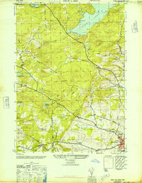
1946 Map of Peck Lake
USGS Topo · Published 1946About this map
Adirondack State Park forms the wooded backdrop for this mid-1940s landscape, where the high country transitions into the settled valleys of Johnstown. The dominant water feature, Peck Lake, is surrounded by small rural institutions like the Peck Lake School and the North Bush Ch, illustrating the tight-knit community structure of the era. To the south, the topography flattens as it approaches the city, marked by the expansive Sir William Johnson State Park.
Find a feature on this map
50 named features on this map. Tap any name to fly to it.
Don’t see what you’re looking for? This feature index may not catch every label — zoom into the map to look around manually.
Map Details
Editions of this 1946 Peck Lake Map
This is the sole edition of this map. No revisions or reprints were ever made.
Other maps of this area

1896 · Fonda
USGS Topo · 1:62,500

1898 · Fonda
USGS Topo · 1:62,500

1898 · Canajoharie
USGS Topo · 1:62,500

1900 · Canajoharie
USGS Topo · 1:62,500

1901 · Lassellsville
USGS Topo · 1:62,500

1902 · Canajoharie
USGS Topo · 1:62,500

1902 · Fonda
USGS Topo · 1:62,500

1903 · Gloversville
USGS Topo · 1:62,500

1903 · Lassellsville
USGS Topo · 1:62,500

1943 · Gloversville
USGS Topo · 1:62,500