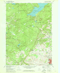
1970 Map of Peck Lake
USGS Topo · Published 1972About this map
Peck Lake sits at the heart of this Adirondack landscape, where the transition from managed state forests to early urban development is clearly visible. The southern reaches of the Adirondack State Park give way to extensive State Reforestation Areas, reflecting a 20th-century landscape of conservation and resource management. The map details the outskirts of Gloversville and Johnstown, showing the expansion of these industrial hubs toward the wooded hills.
Find a feature on this map
50 named features on this map. Tap any name to fly to it.
Don’t see what you’re looking for? This feature index may not catch every label — zoom into the map to look around manually.
Map Details
Editions of this 1970 Peck Lake Map
This is the sole edition of this map. No revisions or reprints were ever made.
Other maps of this area

1896 · Fonda
USGS Topo · 1:62,500

1898 · Fonda
USGS Topo · 1:62,500

1898 · Canajoharie
USGS Topo · 1:62,500

1900 · Canajoharie
USGS Topo · 1:62,500

1901 · Lassellsville
USGS Topo · 1:62,500

1902 · Canajoharie
USGS Topo · 1:62,500

1902 · Fonda
USGS Topo · 1:62,500

1903 · Gloversville
USGS Topo · 1:62,500

1903 · Lassellsville
USGS Topo · 1:62,500

1943 · Gloversville
USGS Topo · 1:62,500