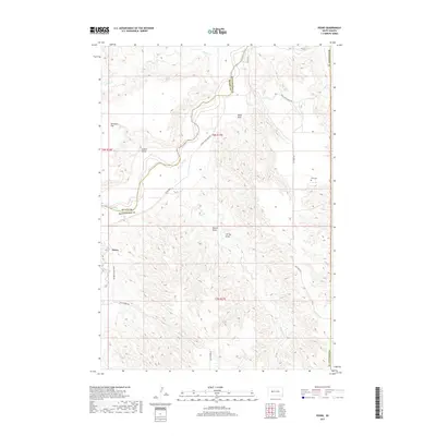
2017 Map of Pedro
USGS Topo · Published 2017About this map
The Cheyenne River snakes through this high-plains landscape, defining the boundary between Meade and Pennington counties. Near the southwestern corner, the small settlement of Pedro sits at the junction of local routes like Quinn-Pedro Rd, serving as a focal point for the surrounding ranching and agricultural land. The terrain is marked by a complex system of drainages, including Green Draw, Webb Draw, and Carley Draw, which carve into the plateau surrounding Davidson Flat. For those tracing local history or genealogy, the presence of the Rose Cem in the eastern hills and isolated water sources like Indian Spring and Huss Spring highlight the locations of early rural activity. The map captures a contemporary look at this traditional cattle-country landscape where named creeks like Mixes Food Cr and Timber Cr provide critical drainage in an otherwise arid environment.
Find a feature on this map
22 named features on this map. Tap any name to fly to it.
Don’t see what you’re looking for? This feature index may not catch every label — zoom into the map to look around manually.
Map Details
Editions of this 2017 Pedro Map
This is the sole edition of this map. No revisions or reprints were ever made.
Other maps of this area

1953 · Rapid City
USGS Topo · 1:250,000

1954 · Pierre
USGS Topo · 1:250,000

1955 · Bridger
USGS Topo · 1:24,000

1955 · Pedro
USGS Topo · 1:24,000

1955 · Pedro NW
USGS Topo · 1:24,000

1955 · Creighton
USGS Topo · 1:24,000

1955 · Howes
USGS Topo · 1:24,000

1955 · Pedro SE
USGS Topo · 1:24,000

1955 · Hilland NW
USGS Topo · 1:24,000

1957 · Rapid City
USGS Topo · 1:250,000