
1972 Map of Pelican Keys
USGS Topo · Published 1976About this map
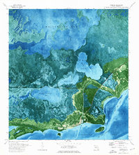
Everglades National Park encompasses this expansive marine and coastal environment in Monroe County, where the transition from open water to shallow mudflats is meticulously detailed via orthophotography. The area is dominated by Whipray Basin and the shallow reaches of the Dildo Key Bank, revealing the intricate textures of the submerged landscape and the scattered mangrove islands that define the Florida Bay. Small, isolated landforms such as Pelican Keys, Dead Terrapin Key, and Cluett Key are visible, many named for local wildlife or maritime features. This 1972 orthophotomap, based on aerial photography from the previous year, provides a precise view of the shoals and channels during a period of environmental preservation. It serves as a visual record of the shoreline and benthic patterns before natural shifts or modern sea-level changes altered the configurations of islands like Buoy Key and Whipray Keys.
Find a feature on this map
19 named features on this map. Tap any name to fly to it.
Don’t see what you’re looking for? This feature index may not catch every label — zoom into the map to look around manually.
Map Details
Editions of this 1972 Pelican Keys Map
This is the sole edition of this map. No revisions or reprints were ever made.
Other maps of this area

1956 · Miami
USGS Topo · 1:250,000

1958 · Miami
USGS Topo · 1:250,000

1971 · Upper Matecumbe Key
USGS Topo · 1:24,000

1972 · Schooner Bank
USGS Topo · 1:24,000

1972 · Madeira Bay
USGS Topo · 1:24,000

1972 · West Lake
USGS Topo · 1:24,000

1972 · Buchanan Keys
USGS Topo · 1:24,000

1972 · Calusa Keys
USGS Topo · 1:24,000

1972 · Clive Key
USGS Topo · 1:24,000
1973 · Flamingo
USGS Topo · 1:24,000