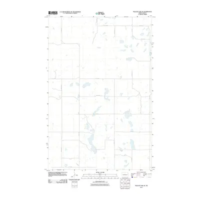
2011 Map of Pelican Lake SE
USGS Topo · Published 2011About this map
Glacial prairie potholes and a strictly organized grid of rural roads define this Sheridan County landscape in the early 21st century. The terrain is dominated by hundreds of small, unlabelled wetlands and depressions, characteristic of the northern plains. Human presence is marked by a precise network of section-line roads, including Center Ave N and 11th St NW, which facilitate access to the surrounding agricultural land. The map reveals how the modern township and range survey system continues to dictate the layout of travel, with routes like 1st Ave NW and 9th St NW forming the primary skeleton for movement through this sparse, water-dotted territory.
Find a feature on this map
14 named features on this map. Tap any name to fly to it.
Don’t see what you’re looking for? This feature index may not catch every label — zoom into the map to look around manually.
Map Details
Editions of this 2011 Pelican Lake SE Map
This is the sole edition of this map. No revisions or reprints were ever made.
Other maps of this area

1945 · Pelican Lake
USGS Topo · 1:62,500

1947 · Pelican Lake
USGS Topo · 1:62,500

1947 · Lincoln Valley
USGS Topo · 1:62,500

1954 · McClusky
USGS Topo · 1:250,000

1958 · McClusky
USGS Topo · 1:250,000

1959 · Pickardville
USGS Topo · 1:24,000

1959 · Mercer
USGS Topo · 1:24,000

1959 · McClusky
USGS Topo · 1:24,000
1960 · Lincoln Valley SW
USGS Topo · 1:24,000
1960 · Lincoln Valley NW
USGS Topo · 1:24,000