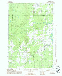
1985 Map of Pelkie
USGS Topo · Published 1985About this map
Limestone Mountain rises as a prominent landmark in this portion of the Upper Peninsula, situated near the border of Houghton and Baraga counties. The landscape is defined by the convergence of the Sturgeon River and the Otter River, which wind through a mosaic of public lands including the Copper Country State Forest and the Ottawa National Forest. Small settlements such as Pelkie, Alston, and Elo serve as focal points for local residency and commerce, connected by a network of rural routes and the West Grade road. This 1980s-era survey illustrates a region where natural resource management and small-town settlement patterns persist alongside numerous waterways like Silver Creek and Farce Creek, reflecting the area's timber and recreational character.
Find a feature on this map
23 named features on this map. Tap any name to fly to it.
Don’t see what you’re looking for? This feature index may not catch every label — zoom into the map to look around manually.
Map Details
Editions of this 1985 Pelkie Map
This is the sole edition of this map. No revisions or reprints were ever made.
Other maps of this area

1954 · Rousseau
USGS Topo · 1:62,500

1954 · Pelkie
USGS Topo · 1:62,500

1954 · Winona
USGS Topo · 1:62,500

1954 · Sidnaw
USGS Topo · 1:62,500

1958 · Iron River
USGS Topo · 1:250,000

1960 · Iron River
USGS Topo · 1:250,000

1961 · Iron River
USGS Topo · 1:250,000

1967 · Iron River
USGS Topo · 1:250,000
1982 · Nisula
USGS Topo · 1:25,000
1982 · Donken
USGS Topo · 1:25,000