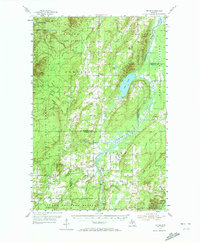
1954 Map of Pelkie
USGS Topo · Published 1972About this map
Limestone Mountain rises as a prominent landmark in this mid-century view of the Copper Country interior, where the Otter River and Sturgeon River converge. The landscape is a mix of agricultural clearings and dense woodlands across the Baraga State Forest and Ottawa National Forest. Small farming communities and Finnish settlements like Pelkie, Tapiola, and Elo are centers of local life, each marked by its own schools, churches like Elo Ch, and family-named cemeteries such as Kargi Cem and Askel Cem.
Find a feature on this map
40 named features on this map. Tap any name to fly to it.
Don’t see what you’re looking for? This feature index may not catch every label — zoom into the map to look around manually.
Map Details
Editions of this 1954 Pelkie Map
Other maps of this area

1915 · Houghton
USGS Topo · 1:62,500

1946 · Chassell
USGS Topo · 1:24,000

1946 · South Range
USGS Topo · 1:24,000

1948 · South Range
USGS Topo · 1:24,000

1948 · Chassell
USGS Topo · 1:24,000

1954 · Graveraet River
USGS Topo · 1:24,000

1954 · Rousseau
USGS Topo · 1:62,500

1954 · Keweenaw Bay
USGS Topo · 1:62,500

1954 · Point Mills
USGS Topo · 1:24,000

1954 · Pelkie
USGS Topo · 1:62,500