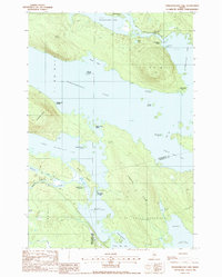
1988 Map of Pemadumcook Lake
USGS Topo · Published 1988About this map
Pemadumcook Lake and the Penobscot River anchor this late-twentieth-century landscape, illustrating the remote sporting and timber heritage of the Maine North Woods. The map details a complex network of interconnected waterways, including Lower Jo-Mary Lake and Middle Jo-Mary Lake, separated by timbered land and the prominent Lincoln Ridge. Evidence of the region's logging history is found at the Boom House near Ambajejus Lake, while seasonal recreational use is noted at Ambajejus Camps and Buckhorn Camps. The Appalachian Trail winds through the southwestern quadrant, crossing over a scenic footbridge at Mud Brook. This survey captures the traditional township boundaries, including T 4 Indian Purchase and various West of East Line (WELS) designations, which continue to define land management in this sparsely settled wilderness.
Find a feature on this map
46 named features on this map. Tap any name to fly to it.
Don’t see what you’re looking for? This feature index may not catch every label — zoom into the map to look around manually.
Map Details
Editions of this 1988 Pemadumcook Lake Map
This is the sole edition of this map. No revisions or reprints were ever made.
Other maps of this area

1927 · Katahdin
USGS Topo · 1:48,000

1930 · Katahdin
USGS Topo · 1:62,500

1949 · Katahdin
USGS Topo · 1:62,500

1951 · Norcross
USGS Topo · 1:62,500

1952 · Jo-Mary Mountain
USGS Topo · 1:62,500

1954 · Harrington Lake
USGS Topo · 1:62,500

1954 · Millinocket
USGS Topo · 1:250,000

1958 · Millinocket
USGS Topo · 1:250,000

1960 · Millinocket
USGS Topo · 1:250,000
1978 · Trout Mountain
USGS Topo · 1:24,000