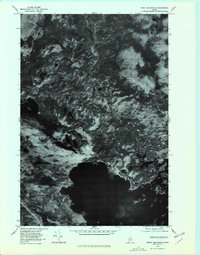
1978 Map of Trout Mountain
USGS Topo · Published 1981About this map
Millinocket Lake dominates the southern portion of this orthophotoquad, showing the intricate shoreline and surrounding wetlands of northern Maine in the late 1970s. The aerial imagery captures the heavily forested landscape where Sandy Stream drains southward toward the lake basin. Rising above the dense timber is the distinct profile of Trout Mountain, a landmark in this undeveloped region.
Find a feature on this map
6 named features on this map. Tap any name to fly to it.
Don’t see what you’re looking for? This feature index may not catch every label — zoom into the map to look around manually.
Map Details
Editions of this 1978 Trout Mountain Map
This is the sole edition of this map. No revisions or reprints were ever made.
Other maps of this area

1927 · Katahdin
USGS Topo · 1:48,000

1930 · Katahdin
USGS Topo · 1:62,500

1949 · Katahdin
USGS Topo · 1:62,500

1951 · Norcross
USGS Topo · 1:62,500

1951 · Millinocket
USGS Topo · 1:62,500

1953 · Stacyville
USGS Topo · 1:62,500

1954 · Millinocket
USGS Topo · 1:250,000

1958 · Millinocket
USGS Topo · 1:250,000

1960 · Millinocket
USGS Topo · 1:250,000
1975 · Stacyville NW
USGS Topo · 1:24,000