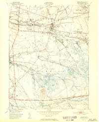
1951 Map of Pemberton
USGS Topo · Published 1951About this map
Pemberton and its neighboring villages in Burlington County are defined by the winding paths of the North Branch Rancocas Creek and South Branch Rancocas Creek. This post-war era landscape reveals a mix of old industrial activity and expanding institutional footprints, including the Brick Kilns near Birmingham and a cluster of county facilities like the Welfare Home and Newcomb Chest Hosp near New Lisbon. To the northeast, the Fort Dix Military Reservation occupies a significant portion of the terrain, while the southern reaches are dominated by agricultural and water-intensive land uses, notably the Budds Cranberry Bogs and the extensive Bear Swamp. The mapping of small, specific locales such as Comical Corners, Retreat, and Stop provides a precise view of the rural crossroads that linked these milling and farming communities together. Along the southern edge, the John Davison Rockefeller Memorial Highway serves as a major transit corridor through the pine-laden lowlands.
Find a feature on this map
56 named features on this map. Tap any name to fly to it.
Don’t see what you’re looking for? This feature index may not catch every label — zoom into the map to look around manually.
Map Details
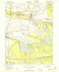
Editions of this 1951 Pemberton Map
2 editions found
Other maps of this area

1888 · Bordentown
USGS Topo · 1:62,500

1888 · Pemberton
USGS Topo · 1:62,500

1888 · Mount Holly
USGS Topo · 1:62,500

1890 · Burlington
USGS Topo · 1:62,500

1893 · Bordentown
USGS Topo · 1:62,500

1893 · Burlington
USGS Topo · 1:62,500

1894 · Pemberton
USGS Topo · 1:62,500

1894 · Mount Holly
USGS Topo · 1:62,500

1898 · Pemberton
USGS Topo · 1:62,500

1898 · Mount Holly
USGS Topo · 1:62,500
Featured Places
- Southampton Township, NJ
- Tabernacle Township, NJ
- Eastampton Township, NJ
- Springfield Township, NJ
- Pemberton, NJ