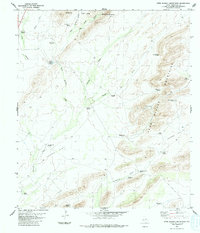
1983 Map of Pena Blanca Mountains
USGS Topo · Published 1984About this map
The Peña Blanca Mountains and Wood Hollow Mountains dominate this Brewster County landscape, defining a region where water management was essential to ranching operations. In the late 1970s, a network of windmills and tanks supported activity across the expansive terrain of Lightning Flat and Dagger Flat. Isolated water sources such as Reed Spring and the Wood Hollow Tank provided critical points of relief in an arid environment shaped by seasonal drainages like Hackberry Creek and Reynolds Creek. The placement of numerous named windmills, including the Little Shipping Trap Windmill and Saddle Gap Windmill, illustrates the extensive infrastructure required to maintain livestock in this high-desert territory. These features reveal the practical geography of West Texas land use, where family-named landmarks and functional sites like the Barrett Corner Windmill served as the primary coordinates for local life and navigation.
Find a feature on this map
30 named features on this map. Tap any name to fly to it.
Don’t see what you’re looking for? This feature index may not catch every label — zoom into the map to look around manually.
Map Details
Editions of this 1983 Pena Blanca Mountains Map
This is the sole edition of this map. No revisions or reprints were ever made.
Other maps of this area

1917 · Santiago Peak
USGS Topo · 1:62,500

1917 · Hood Spring
USGS Topo · 1:62,500

1918 · Bone Spring
USGS Topo · 1:125,000

1918 · Hood Spring
USGS Topo · 1:62,500

1918 · Santiago Peak
USGS Topo · 1:62,500

1920 · Monument Spring
USGS Topo · 1:62,500

1920 · Marathon
USGS Topo · 1:62,500

1921 · Monument Spring
USGS Topo · 1:62,500

1921 · Marathon
USGS Topo · 1:62,500

1931 · Hood Spring
USGS Topo · 1:62,500