
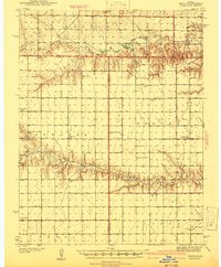
1941 Map of Pence
USGS Topo · Published 1941About this map
Chalk Creek and Ladder Creek carve distinct paths across the high plains of Western Kansas, defining a landscape of sparse rural settlements and remote schoolhouses. Surveyed in 1939 and published in 1941, this map captures the region at the end of the Great Depression, when the local social structure was anchored by one-room schoolhouses like Liberty Sch, Enterprise Sch, and Prairie View Sch. These institutions, scattered across townships such as Edwards and Paxton, reflect the density of the homesteading era before later 20th-century school consolidations transformed the rural educational landscape. The map provides a look at the intersection of Logan, Wichita, and Scott counties, where the Pence Cem and Pence Sch mark the small community of Pence. The drainage patterns of Beaver Creek further illustrate the reliance on natural watercourses in an otherwise arid environment, revealing the geographic constraints on early development in the High Plains.
Find a feature on this map
19 named features on this map. Tap any name to fly to it.
Don’t see what you’re looking for? This feature index may not catch every label — zoom into the map to look around manually.
Map Details
Editions of this 1941 Pence Map
2 editions found
Other maps of this area

1939 · Lake Mc Bride
USGS Topo · 1:24,000

1939 · Sandon
USGS Topo · 1:62,500

1939 · Pence
USGS Topo · 1:62,500

1940 · Scott City
USGS Topo · 1:62,500

1941 · Modoc
USGS Topo · 1:62,500

1942 · Sandon
USGS Topo · 1:62,500

1942 · Lake Mc Bride
USGS Topo · 1:31,680

1951 · Scott City
USGS Topo · 1:62,500

1951 · Modoc
USGS Topo · 1:62,500

1955 · Scott City
USGS Topo · 1:250,000