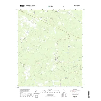
2020 Map of Penfield
USGS Topo · Published 2020About this map
Penfield and Woodville anchor this corner of Greene County, where the transition from agriculture to protected timberland is evident. The southern portion of the sheet is dominated by the Oconee National Forest, featuring the recreation-focused Town Creek Loop A and Town Creek Loop B alongside the Town Creek Trl. The landscape is defined by a series of family-named cemeteries that reflect generations of local settlement, including the Moore Cem, Janes Cem, and Finley Cem. Watercourses like McWhorter Cr and Fishing Cr wind through the hills, connecting the smaller hamlets. To the north, Maxeys sits at the edge of Oglethorpe County, connected by a network of rural routes such as Watson Springs Rd and Macedonia Rd. The density of burial sites, such as the Shiloh Baptist Church Cem, provides a significant map of the community’s ancestral footprint across these woods and creek bottoms.
Find a feature on this map
55 named features on this map. Tap any name to fly to it.
Don’t see what you’re looking for? This feature index may not catch every label — zoom into the map to look around manually.
Map Details
Editions of this 2020 Penfield Map
This is the sole edition of this map. No revisions or reprints were ever made.
Other maps of this area

1953 · Athens
USGS Topo · 1:250,000

1958 · Athens
USGS Topo · 1:250,000

1959 · Athens
USGS Topo · 1:250,000

1963 · Athens
USGS Topo · 1:250,000

1964 · Barnett Shoals
USGS Topo · 1:24,000

1965 · Woodville
USGS Topo · 1:24,000

1965 · Union Point
USGS Topo · 1:24,000

1971 · Maxeys
USGS Topo · 1:24,000
1971 · Lexington
USGS Topo · 1:24,000

1972 · Penfield
USGS Topo · 1:24,000