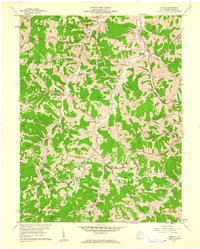
1957 Map of Peniel
USGS Topo · Published 1961About this map
Reedy Creek carves a path through the northern hills of this landscape, flanked by the Baltimore and Ohio railroad corridor. The mid-1950s terrain is marked by a network of narrow ridges and winding hollows, where small rural communities like Billings and Reedyville established roots near the water. Life in these West Virginia hills centered on the numerous country churches and schools that dot the map, including Mt Zion Ch and the Morning Star Sch.
Find a feature on this map
73 named features on this map. Tap any name to fly to it.
Don’t see what you’re looking for? This feature index may not catch every label — zoom into the map to look around manually.
Map Details
Editions of this 1957 Peniel Map
This is the sole edition of this map. No revisions or reprints were ever made.
Other maps of this area

1906 · Kenna
USGS Topo · 1:62,500

1906 · Walton
USGS Topo · 1:62,500

1907 · Kenna
USGS Topo · 1:62,500

1907 · Spencer
USGS Topo · 1:62,500

1907 · Walton
USGS Topo · 1:62,500

1907 · Ripley
USGS Topo · 1:62,500

1926 · Ripley
USGS Topo · 1:62,500

1928 · Spencer
USGS Topo · 1:62,500

1928 · Ripley
USGS Topo · 1:62,500

1954 · Charleston
USGS Topo · 1:250,000