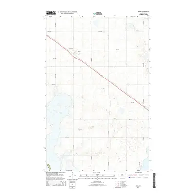
2014 Map of Penn
USGS Topo · Published 2014About this map
The small settlement of Penn anchors this northern Great Plains landscape, situated along the diagonal path of Us-2. This agricultural region on the border of Ramsey and Benson counties is defined by a dense network of section-line roads, including 57th St NE and 50th St NE, which serve the scattered farmsteads and rural infrastructure. A primary focal point for local family history is Saint Paul Cem, located just west of the Penn townsite. The topography is dotted with glacial wetlands and prairie potholes, notably the large basin of Dry Lake in the northeast corner and the northern reaches of Sixmile Bay at the southern edge. The map reveals the precise layout of Ramsey, positioned south of the highway, illustrating the characteristic grain-and-rail settlement patterns that have shaped the North Dakota prairie for generations.
Find a feature on this map
16 named features on this map. Tap any name to fly to it.
Don’t see what you’re looking for? This feature index may not catch every label — zoom into the map to look around manually.
Map Details
Editions of this 2014 Penn Map
This is the sole edition of this map. No revisions or reprints were ever made.
Other maps of this area

1931 · Devils Lake
USGS Topo · 1:62,500

1932 · Grahams Island
USGS Topo · 1:62,500

1950 · Grahams Island
USGS Topo · 1:62,500

1950 · Devils Lake
USGS Topo · 1:62,500

1951 · Grahams Island
USGS Topo · 1:24,000

1951 · Tilden
USGS Topo · 1:24,000

1951 · Grand Harbor
USGS Topo · 1:24,000

1951 · Camp Grafton
USGS Topo · 1:24,000

1951 · Minnewaukan East
USGS Topo · 1:24,000

1951 · Penn
USGS Topo · 1:24,000