
1951 Map of Grahams Island
USGS Topo · Published 1951About this map
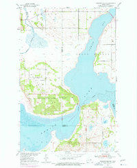
Grahams Island dominates this mid-century topographic view of the Devils Lake basin, an area shaped by fluctuating water levels and a legacy of frontier defense. The landscape is defined by the extensive reaches of Sixmile Bay, Pelican Bay, and Grand Harbor, which surround the central landmass. A notable historical marker on the island is the Old Military Reservation Boundary, providing a geographic anchor for local historians and researchers studying the region's early administration. Rural development is evidenced by the placement of School No 1 and School No 2, serving the scattered homesteads across the island and the mainland along the Benson and Ramsey County line. The map captures a moment before modern hydrologic changes, reflecting the natural shoreline and the early road network as they existed in the early 1950s.
Find a feature on this map
11 named features on this map. Tap any name to fly to it.
Don’t see what you’re looking for? This feature index may not catch every label — zoom into the map to look around manually.
Map Details
Editions of this 1951 Grahams Island Map
2 editions found
Other maps of this area

1928 · Tokio
USGS Topo · 1:62,500

1931 · Oberon
USGS Topo · 1:62,500

1931 · Tokio
USGS Topo · 1:62,500

1931 · Devils Lake
USGS Topo · 1:62,500

1932 · Grahams Island
USGS Topo · 1:62,500

1950 · Grahams Island
USGS Topo · 1:62,500

1950 · Devils Lake
USGS Topo · 1:62,500

1950 · Oberon
USGS Topo · 1:62,500

1951 · Crow Hill
USGS Topo · 1:24,000

1951 · Oberon
USGS Topo · 1:24,000