
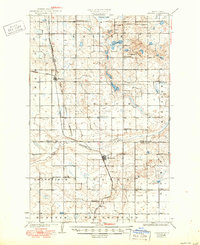
1931 Map of Oberon
USGS Topo · Published 1931About this map
Oberon and Sheyenne sit as the primary rail-oriented hubs in this 1928 survey of the North Dakota prairie. The Northern Pacific railroad cuts a diagonal line across the landscape, linking these towns to the smaller siding at Divide and the surrounding agricultural townships of Lake, Rock, Grandfield, and Gates. The influence of the Fort Totten Indian Reservation is visible along the eastern edge of the quadrangle, where the boundary intersects the glacial terrain and numerous prairie potholes including Twin Lakes.
Find a feature on this map
23 named features on this map. Tap any name to fly to it.
Don’t see what you’re looking for? This feature index may not catch every label — zoom into the map to look around manually.
Map Details
Editions of this 1931 Oberon Map
2 editions found
Other maps of this area

1928 · Tokio
USGS Topo · 1:62,500

1931 · Tokio
USGS Topo · 1:62,500

1931 · Devils Lake
USGS Topo · 1:62,500

1932 · Flora
USGS Topo · 1:62,500

1932 · Grahams Island
USGS Topo · 1:62,500

1944 · Brantford
USGS Topo · 1:62,500

1946 · Brantford
USGS Topo · 1:62,500

1948 · New Rockford
USGS Topo · 1:62,500

1948 · Cathay
USGS Topo · 1:62,500

1949 · Munster
USGS Topo · 1:24,000