
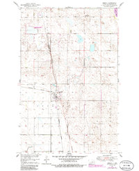
1951 Map of Oberon
USGS Topo · Published 1951About this map
The Northern Pacific railroad corridor serves as the primary axis for this North Dakota landscape, passing directly through the community of Oberon and the nearby settlement of Lallie. Mapped in the early 1950s, the terrain is defined by its glacial history, peppered with numerous small depressions and sloughs. An Old Indian Reservation Boundary bisects the region vertically, marking a significant historical administrative line across the prairie. Local life at mid-century is anchored by rural landmarks such as Hillside Cem and Lakeview Sch No 1 in the northeast. The presence of several Gravel Pits and a larger Gravel Pit near the rail line suggests an economy supported by both agriculture and resource extraction, while the shoreline of Devils Lake reaches into the upper corner of the map.
Find a feature on this map
12 named features on this map. Tap any name to fly to it.
Don’t see what you’re looking for? This feature index may not catch every label — zoom into the map to look around manually.
Map Details
Editions of this 1951 Oberon Map
2 editions found
Other maps of this area

1931 · Oberon
USGS Topo · 1:62,500

1932 · Flora
USGS Topo · 1:62,500

1932 · Grahams Island
USGS Topo · 1:62,500

1950 · Oberon SW
USGS Topo · 1:24,000

1950 · Sheyenne
USGS Topo · 1:24,000

1950 · Grahams Island
USGS Topo · 1:62,500

1950 · Oberon
USGS Topo · 1:62,500

1951 · Crow Hill
USGS Topo · 1:24,000

1951 · Flora SE
USGS Topo · 1:24,000

1951 · Grahams Island
USGS Topo · 1:24,000