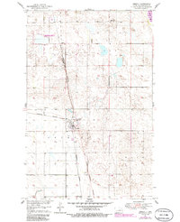
1951 Map of Oberon
USGS Topo · Published 1986About this map
Oberon stands as a primary focal point in this Benson County landscape, situated along the Burlington Northern railroad line. The settlement pattern is defined by its proximity to the rail corridor, which runs north through Lallie toward the shores of Devils Lake visible in the northeast corner. This 1951 survey, photorevised in 1986, delineates the Indian Reservation Boundary cutting through the center of the quadrangle, reflecting the complex jurisdictional geography of the region. Local infrastructure is marked by rural landmarks such as Lakeview Sch No 1 and the Hillside Cem located just north of the Oberon townsite. Large tracts of land are designated as the National Waterfowl Production Area, highlighting the significance of the prairie pothole terrain for wildlife conservation. The presence of multiple Gravel Pits suggests a local economy tied to the extraction of glacial deposits common to this part of North Dakota.
Find a feature on this map
16 named features on this map. Tap any name to fly to it.
Don’t see what you’re looking for? This feature index may not catch every label — zoom into the map to look around manually.
Map Details
Editions of this 1951 Oberon Map
2 editions found
Other maps of this area

1931 · Oberon
USGS Topo · 1:62,500

1932 · Flora
USGS Topo · 1:62,500

1932 · Grahams Island
USGS Topo · 1:62,500

1950 · Oberon SW
USGS Topo · 1:24,000

1950 · Sheyenne
USGS Topo · 1:24,000

1950 · Grahams Island
USGS Topo · 1:62,500

1950 · Oberon
USGS Topo · 1:62,500

1951 · Crow Hill
USGS Topo · 1:24,000

1951 · Oberon
USGS Topo · 1:24,000

1951 · Flora SE
USGS Topo · 1:24,000