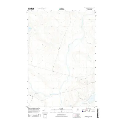
2014 Map of Penobscot Farm
USGS Topo · Published 2014About this map
Penobscot Farm sits at the heart of this North Maine Woods landscape, positioned where several historic timber and access routes converge. The terrain is dominated by the winding course of the West Branch Penobscot River, which flows through a network of significant waterways including the slow-moving Cassidy Deadwater and the southern reaches of Lobster Lake. The map details an extensive network of logging roads that underscore the region's industrial heritage, most notably the prominent east-west artery of the Golden Rd and its intersections with Ragmuff Rd and Poulin Rd. Toward the southeast, the landscape transitions into the smaller hydrological systems of Little Lobster Lake and Little Lobster Stream, while Lobster Stream provides a central corridor through the township. This survey illustrates the modern configuration of a working forest landscape where the traditional river-driven economy has been replaced by the heavy-duty road networks necessary for contemporary timber operations.
Find a feature on this map
16 named features on this map. Tap any name to fly to it.
Don’t see what you’re looking for? This feature index may not catch every label — zoom into the map to look around manually.
Map Details
Editions of this 2014 Penobscot Farm Map
This is the sole edition of this map. No revisions or reprints were ever made.
Other maps of this area

1954 · Chesuncook
USGS Topo · 1:62,500

1954 · North East Carry
USGS Topo · 1:62,500

1954 · Caucomgomoc Lake
USGS Topo · 1:62,500

1954 · Grant Farm
USGS Topo · 1:62,500

1954 · Presque Isle
USGS Topo · 1:250,000

1954 · Millinocket
USGS Topo · 1:250,000

1958 · Presque Isle
USGS Topo · 1:250,000

1958 · Millinocket
USGS Topo · 1:250,000

1958 · Chesuncook
USGS Topo · 1:62,500

1958 · Caucomgomoc Lake
USGS Topo · 1:62,500
Featured Places
- Northeast Carry Township, ME
- T4 R14 WELS, ME
- T4 R15 WELS, ME
- Lobster Township, ME
- Piscataquis County, ME