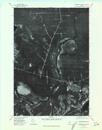
1977 Map of Penobscot Farm
USGS Topo · Published 1981About this map
Penobscot Farm anchors this orthophotoquad, which uses aerial photography to document the Piscataquis County timberlands of the late 1970s. The landscape is defined by the winding course of the West Branch Penobscot River, a historical artery for the region's logging operations. The photographic detail reveals the extensive network of logging roads and clearings that characterize the industrial forest, providing a visual record of land management patterns before modern reforestation. To the southeast, Lobster Stream feeds into the main river channel, while the secluded waters of Little Lobster Lake are visible in the lower right corner. This survey is a stark departure from traditional line-drawn maps, offering researchers a literal view of the vegetation density and trackways as they existed during the 1977 flyover.
Find a feature on this map
4 named features on this map. Tap any name to fly to it.
Don’t see what you’re looking for? This feature index may not catch every label — zoom into the map to look around manually.
Map Details
Editions of this 1977 Penobscot Farm Map
This is the sole edition of this map. No revisions or reprints were ever made.
Other maps of this area

1954 · Chesuncook
USGS Topo · 1:62,500

1954 · North East Carry
USGS Topo · 1:62,500

1954 · Caucomgomoc Lake
USGS Topo · 1:62,500

1954 · Grant Farm
USGS Topo · 1:62,500

1954 · Presque Isle
USGS Topo · 1:250,000

1954 · Millinocket
USGS Topo · 1:250,000

1958 · Presque Isle
USGS Topo · 1:250,000

1958 · Millinocket
USGS Topo · 1:250,000

1958 · Chesuncook
USGS Topo · 1:62,500

1958 · Caucomgomoc Lake
USGS Topo · 1:62,500
Featured Places
- Northeast Carry Township, ME
- T4 R14 WELS, ME
- Lobster Township, ME
- T4 R15 WELS, ME
- Piscataquis County, ME