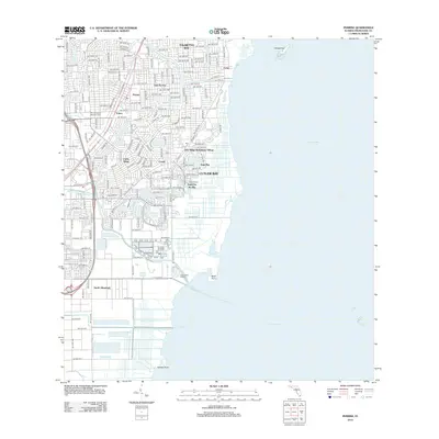
2012 Map of Perrine
USGS Topo · Published 2012About this map
Biscayne Bay defines the eastern edge of this coastal Florida landscape, where the dense suburban grids of Palmetto Bay and Cutler Bay meet the Atlantic shoreline. The map illustrates a complex network of managed waterways essential to the region's development, including the Cutler Drain Canal Number C-100 and Black Cr Canal Number C-1. These channels cut through established residential communities like Cutler Ridge, Saga Bay, and Lakes by the Bay. Localized neighborhoods and historical settlement points such as Perrine, East Perrine, and Peters are clearly delineated within the street hierarchy. Along the coast, the transition from developed land to the marine environment is marked by Black Point Marina and the isolated Chicken Key, reflecting the area's dual character as a modern residential hub and a gateway to the coastal ecosystem.
Find a feature on this map
92 named features on this map. Tap any name to fly to it.
Don’t see what you’re looking for? This feature index may not catch every label — zoom into the map to look around manually.
Map Details
Editions of this 2012 Perrine Map
This is the sole edition of this map. No revisions or reprints were ever made.
Other maps of this area

1947 · Key Biscayne
USGS Topo · 1:24,000

1948 · Soldier Key
USGS Topo · 1:24,000

1949 · South Miami NW
USGS Topo · 1:24,000

1949 · Elliott Key
USGS Topo · 1:24,000

1949 · Key Biscayne
USGS Topo · 1:24,000

1949 · Arsenicker Keys
USGS Topo · 1:24,000

1949 · Goulds
USGS Topo · 1:24,000

1949 · Perrine
USGS Topo · 1:24,000

1950 · Homestead
USGS Topo · 1:24,000

1950 · South Miami
USGS Topo · 1:24,000