
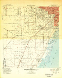
1950 Map of South Miami
USGS Topo · Published 1950About this map
Coral Gables and South Miami dominate this post-war landscape, showing the rapid expansion of the metropolitan area toward the Everglades. The map features the sprawling campus of the University of Miami and the historic Venetian Pool, while the Florida East Coast and Seaboard Air Line railroads provide the primary transportation spine for the region. Aviation infrastructure is prominent with both Tamiami Airport and Browns Airport present, reflecting the era's mid-century aviation boom. Along the shoreline of Biscayne Bay, Matheson Hammock Park and the U S Plant Introduction Garden preserve green spaces as residential developments like Coconut Grove and Olympic Heights begin to fill in the surrounding acreage. Further south, the rural character persists near Kendall and Rockdale, where limestone extraction is evidenced by numerous Borrow Pit labels and the institutional presence of the Dade Co Stockade and Dade County Home and Hospital.
Find a feature on this map
51 named features on this map. Tap any name to fly to it.
Don’t see what you’re looking for? This feature index may not catch every label — zoom into the map to look around manually.
Map Details
Editions of this 1950 South Miami Map
2 editions found
Other maps of this area

1947 · Key Biscayne
USGS Topo · 1:24,000

1948 · Soldier Key
USGS Topo · 1:24,000

1949 · South Miami NW
USGS Topo · 1:24,000

1949 · Key Biscayne
USGS Topo · 1:24,000

1949 · Goulds
USGS Topo · 1:24,000

1949 · Perrine
USGS Topo · 1:24,000

1950 · Hialeah
USGS Topo · 1:24,000

1950 · Miami
USGS Topo · 1:24,000

1955 · South Miami NW
USGS Topo · 1:24,000

1956 · Goulds
USGS Topo · 1:24,000