
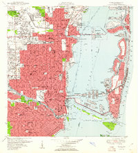
1950 Map of Miami
USGS Topo · Published 1950About this map
Biscayne Bay and its network of man-made islands define this mid-century look at South Florida's rapid expansion. The development of Miami Beach is shown in detail, from the residential clusters on Hibiscus Island and Star Island to the commercial corridors and golf courses like the La Gorce Golf Course. On the mainland, the map documents a mix of civic and military infrastructure, including the U S Naval Air Station Master Field in the northwest and the Orange Bowl and Burdine Stadium area to the south.
Find a feature on this map
154 named features on this map. Tap any name to fly to it.
Don’t see what you’re looking for? This feature index may not catch every label — zoom into the map to look around manually.
Map Details
Editions of this 1950 Miami Map
2 editions found
Other maps of this area

1947 · North Miami
USGS Topo · 1:24,000

1947 · Key Biscayne
USGS Topo · 1:24,000

1949 · Opalocka
USGS Topo · 1:24,000

1949 · Key Biscayne
USGS Topo · 1:24,000

1950 · Hialeah
USGS Topo · 1:24,000

1950 · North Miami
USGS Topo · 1:24,000

1950 · South Miami
USGS Topo · 1:24,000

1956 · South Miami
USGS Topo · 1:24,000

1956 · Miami
USGS Topo · 1:250,000

1958 · Miami
USGS Topo · 1:250,000