
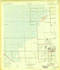
1949 Map of Opalocka
USGS Topo · Published 1949About this map
The U S Naval Air Station and its surrounding airfields dominate this post-war landscape, reflecting the military's significant footprint in South Florida during the late 1940s. The map illustrates a complex aviation network, including West Field, East Field, Master Field, and Municipal Field, all situated near the developing settlement of Opalocka. To the north, the U S Naval Air Gunnery Range extends into the marshy terrain of the Broward and Dade county line, where the land is primarily defined by water management features like the Miami Canal and various Levees.
Find a feature on this map
26 named features on this map. Tap any name to fly to it.
Don’t see what you’re looking for? This feature index may not catch every label — zoom into the map to look around manually.
Map Details
Editions of this 1949 Opalocka Map
2 editions found
Other maps of this area

1947 · North Miami
USGS Topo · 1:24,000

1949 · Fort Lauderdale South
USGS Topo · 1:24,000

1950 · Hialeah
USGS Topo · 1:24,000

1950 · Miami
USGS Topo · 1:24,000

1950 · North Miami
USGS Topo · 1:24,000

1956 · Miami
USGS Topo · 1:250,000

1956 · West Palm Beach
USGS Topo · 1:250,000

1957 · West Palm Beach
USGS Topo · 1:250,000

1958 · West Palm Beach
USGS Topo · 1:250,000

1958 · Miami
USGS Topo · 1:250,000