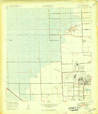
1949 Map of Opalocka
USGS Topo · Published 1949About this map
U S Naval Air Station anchors the landscape of southern Florida in the years following World War II, revealing a region dominated by military aviation and rapid development. This territory, situated along the Broward Co Dade Co line, is defined by extensive airfield complexes including West Field, East Field, and Master Field. To the north, the U S Naval Air Gunnery Range occupies a significant portion of the terrain, illustrating the strategic importance of the area during this era. The settlement of Opalocka is shown just east of the primary air station, while Hialeah begins to expand from the south.
Find a feature on this map
25 named features on this map. Tap any name to fly to it.
Don’t see what you’re looking for? This feature index may not catch every label — zoom into the map to look around manually.
Map Details
Editions of this 1949 Opalocka Map
2 editions found
Other maps of this area

1947 · North Miami
USGS Topo · 1:24,000

1949 · Opalocka
USGS Topo · 1:24,000

1949 · Fort Lauderdale South
USGS Topo · 1:24,000

1950 · Hialeah
USGS Topo · 1:24,000

1950 · Miami
USGS Topo · 1:24,000

1950 · North Miami
USGS Topo · 1:24,000

1956 · Miami
USGS Topo · 1:250,000

1956 · West Palm Beach
USGS Topo · 1:250,000

1957 · West Palm Beach
USGS Topo · 1:250,000

1958 · West Palm Beach
USGS Topo · 1:250,000