
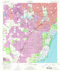
1956 Map of South Miami
USGS Topo · Published 1957About this map
Coral Gables and South Miami expand rapidly across the southern tip of the Florida peninsula in this mid-1950s survey. The landscape is a distinct blend of manicured residential development and tropical conservation, anchored by the University of Miami (North Campus) and the Venetian Pool. The eastern shore along Biscayne Bay reveals a dedication to horticulture and public space, featuring the Fairchild Tropical Garden, the US Plant Introduction Garden, and Matheson Hammock County Park. Inland, the economy is supported by two major rail lines, the Florida East Coast and the Seaboard Air Line, while aviation is represented by Tamiami Airport and Brown Airport. New subdivisions like Westwood Lake and Green-Mar Acres show the post-war suburban growth pushing westward against the Snapper Creek Canal.
Find a feature on this map
87 named features on this map. Tap any name to fly to it.
Don’t see what you’re looking for? This feature index may not catch every label — zoom into the map to look around manually.
Map Details
Editions of this 1956 South Miami Map
2 editions found
Other maps of this area

1947 · Key Biscayne
USGS Topo · 1:24,000

1948 · Soldier Key
USGS Topo · 1:24,000

1949 · South Miami NW
USGS Topo · 1:24,000

1949 · Key Biscayne
USGS Topo · 1:24,000

1949 · Goulds
USGS Topo · 1:24,000

1949 · Perrine
USGS Topo · 1:24,000

1950 · Hialeah
USGS Topo · 1:24,000

1950 · Miami
USGS Topo · 1:24,000

1950 · South Miami
USGS Topo · 1:24,000

1955 · South Miami NW
USGS Topo · 1:24,000