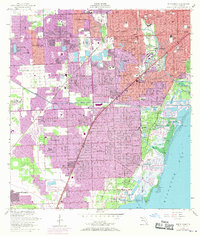
1956 Map of South Miami
USGS Topo · Published 1970About this map
Matheson Hammock County Park and the adjacent Fairchild Tropical Garden define the lush coastal boundary of this mid-century survey. While the established neighborhoods of Coral Gables and Coconut Grove appear as mature urban grids, the purple-tinted revisions of the late 1960s reveal rapid inland expansion through Glenvar Heights and Kendall. The landscape is a transition between formal tropical gardens and the industrial and educational hubs required by a growing population, including the University of Miami campus and the original Tamiami Airport in the northwest.
Find a feature on this map
58 named features on this map. Tap any name to fly to it.
Don’t see what you’re looking for? This feature index may not catch every label — zoom into the map to look around manually.
Map Details
Editions of this 1956 South Miami Map
2 editions found

Other maps of this area

1947 · Key Biscayne
USGS Topo · 1:24,000

1948 · Soldier Key
USGS Topo · 1:24,000

1949 · South Miami NW
USGS Topo · 1:24,000

1949 · Key Biscayne
USGS Topo · 1:24,000

1949 · Goulds
USGS Topo · 1:24,000

1949 · Perrine
USGS Topo · 1:24,000

1950 · Hialeah
USGS Topo · 1:24,000

1950 · Miami
USGS Topo · 1:24,000

1950 · South Miami
USGS Topo · 1:24,000

1955 · South Miami NW
USGS Topo · 1:24,000