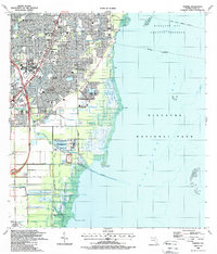
1988 Map of Perrine
USGS Topo · Published 1988About this map
The suburban development of South Dade County meets the protected waters of Biscayne National Park on this 1988 survey. Suburban expansion is evident through the dense residential grids of Perrine, Cutler Ridge, and Goulds, while the shoreline remains largely defined by the Mangrove Preserve and the Deering Estate Preserve. Transportation is dominated by the corridor of Floridas Turnpike and the historic Florida East Coast railway, which slice through the western half of the map.
Find a feature on this map
54 named features on this map. Tap any name to fly to it.
Don’t see what you’re looking for? This feature index may not catch every label — zoom into the map to look around manually.
Map Details
Editions of this 1988 Perrine Map
This is the sole edition of this map. No revisions or reprints were ever made.
Other maps of this area

1947 · Key Biscayne
USGS Topo · 1:24,000

1948 · Soldier Key
USGS Topo · 1:24,000

1949 · South Miami NW
USGS Topo · 1:24,000

1949 · Elliott Key
USGS Topo · 1:24,000

1949 · Key Biscayne
USGS Topo · 1:24,000

1949 · Arsenicker Keys
USGS Topo · 1:24,000

1949 · Goulds
USGS Topo · 1:24,000

1949 · Perrine
USGS Topo · 1:24,000

1950 · Homestead
USGS Topo · 1:24,000

1950 · South Miami
USGS Topo · 1:24,000