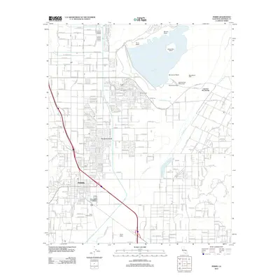
2012 Map of Perris
USGS Topo · Published 2012About this map
Perris and the surrounding Riverside County landscape are defined by the massive Perris Reservoir, which dominates the northern half of this survey. The reservoir, part of the Lake Perris State Rec Area, surrounds Alessandro Island and is bordered by a series of recreation sites including Moreno Beach, Perris Beach, and Bernasconi Beach. The engineering of the Colorado River Aqueduct is visible cutting across the terrain toward the east. South of the water, the map reveals a transition from the established city center of Perris to ranching and aviation lands. Local history and genealogy interests are well-served by the inclusion of the Perris Valley Cem, the Perris Valley Airport, and named agricultural holdings like McCanna Ranch and Mayer Farms. The San Jacinto River meanders through the southern Perris Valley, while the Bernasconi Hills rise to the east, punctuated by the Bernasconi Pass.
Find a feature on this map
82 named features on this map. Tap any name to fly to it.
Don’t see what you’re looking for? This feature index may not catch every label — zoom into the map to look around manually.
Map Details
Editions of this 2012 Perris Map
This is the sole edition of this map. No revisions or reprints were ever made.
Other maps of this area

1901 · Southern California Sheet No. 1
USGS Topo · 1:250,000

1901 · Elsinore
USGS Topo · 1:125,000

1901 · Riverside
USGS Topo · 1:62,500

1904 · Southern California Sheet No. 1
USGS Topo · 1:250,000

1942 · Lake Elsinore
USGS Topo · 1:62,500

1942 · Murrieta
USGS Topo · 1:62,500

1942 · Riverside
USGS Topo · 1:62,500

1942 · Perris
USGS Topo · 1:62,500

1943 · Perris
USGS Topo · 1:62,500

1943 · Riverside
USGS Topo · 1:62,500