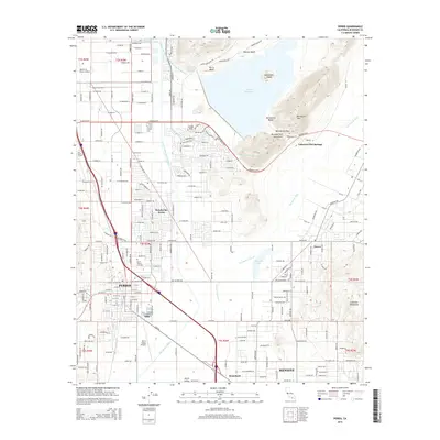
2015 Map of Perris
USGS Topo · Published 2015About this map
Perris and its surrounding inland valleys are defined by a complex network of water management and transportation systems in the early 21st century. The landscape is dominated by the Perris Reservoir, where recreational spots like Perris Beach and Moreno Beach sit alongside major infrastructure, including the Governor Edmund G Brown Jr California Aqueduct and the Colorado River Aqueduct. This period shows the transition of the region from its historical agricultural roots to a modern logistics and residential hub, with March Air Reserve Base bordering the northwest corner and the Perris Valley Airport serving as a local aviation landmark.
Find a feature on this map
209 named features on this map. Tap any name to fly to it.
Don’t see what you’re looking for? This feature index may not catch every label — zoom into the map to look around manually.
Map Details
Editions of this 2015 Perris Map
This is the sole edition of this map. No revisions or reprints were ever made.
Other maps of this area

1901 · Southern California Sheet No. 1
USGS Topo · 1:250,000

1901 · Elsinore
USGS Topo · 1:125,000

1901 · Riverside
USGS Topo · 1:62,500

1904 · Southern California Sheet No. 1
USGS Topo · 1:250,000

1942 · Lake Elsinore
USGS Topo · 1:62,500

1942 · Murrieta
USGS Topo · 1:62,500

1942 · Riverside
USGS Topo · 1:62,500

1942 · Perris
USGS Topo · 1:62,500

1943 · Perris
USGS Topo · 1:62,500

1943 · Riverside
USGS Topo · 1:62,500