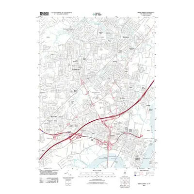
2011 Map of Perth Amboy
USGS Topo · Published 2011About this map
Perth Amboy and its surrounding industrial and residential suburbs appear here during a period of dense suburbanization, shaped by the massive infrastructure of the Garden State Pkwy and the intricate rail network at Perth Amboy Junction. The landscape is a complex map of early 21st-century New Jersey life, where historic sites like the Metuchen Colonial Cemetery sit alongside modern transit corridors. Significant landmarks such as the Edison Memorial Tower and the twin spans of the Thomas A Edison Bridge and Governor Alfred E Driscoll Bridge over the Raritan River define the local skyline. The map reveals the fine-grained development of neighborhoods like Menlo Park, Clara Barton, and Iselin, as well as the industrial waterfronts at Port Reading and Sewaren along the Arthur Kill. Numerous memorial sites, including Beth Israel Memorial Park and Saint James Cemetery, offer rich detail for those researching local family history and the evolution of these established communities.
Find a feature on this map
90 named features on this map. Tap any name to fly to it.
Don’t see what you’re looking for? This feature index may not catch every label — zoom into the map to look around manually.
Map Details
Editions of this 2011 Perth Amboy Map
This is the sole edition of this map. No revisions or reprints were ever made.
Other maps of this area

1888 · Plainfield
USGS Topo · 1:62,500

1888 · New Brunswick
USGS Topo · 1:62,500

1888 · Sandy Hook
USGS Topo · 1:62,500

1893 · New Brunswick
USGS Topo · 1:62,500

1893 · Plainfield
USGS Topo · 1:62,500

1893 · Sandy Hook
USGS Topo · 1:62,500

1898 · Plainfield
USGS Topo · 1:62,500

1898 · Staten Island
USGS Topo · 1:62,500

1900 · Passaic
USGS Topo · 1:125,000

1900 · Staten Island
USGS Topo · 1:62,500