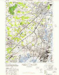
1947 Map of Perth Amboy
USGS Topo · Published 1947About this map
Perth Amboy stands at a vital industrial crossroads in 1947, where the Raritan River meets the Arthur Kill. This survey reveals a landscape heavily shaped by manufacturing and shipping, featuring the Raritan Copper Works, Am Smelting & Refining Co, and the Barber Asphalt Co lining the waterfront. Inland, the area transitions from dense urban grids to the growing townships of Woodbridge and Raritan, marked by local landmarks like the Edison Mem Beacon and the NJ State Reformatory.
Find a feature on this map
126 named features on this map. Tap any name to fly to it.
Don’t see what you’re looking for? This feature index may not catch every label — zoom into the map to look around manually.
Map Details
Editions of this 1947 Perth Amboy Map
This is the sole edition of this map. No revisions or reprints were ever made.
Other maps of this area

1888 · Plainfield
USGS Topo · 1:62,500

1888 · New Brunswick
USGS Topo · 1:62,500

1888 · Sandy Hook
USGS Topo · 1:62,500

1893 · New Brunswick
USGS Topo · 1:62,500

1893 · Plainfield
USGS Topo · 1:62,500

1893 · Sandy Hook
USGS Topo · 1:62,500

1898 · Plainfield
USGS Topo · 1:62,500

1898 · Staten Island
USGS Topo · 1:62,500

1900 · Passaic
USGS Topo · 1:125,000

1900 · Staten Island
USGS Topo · 1:62,500