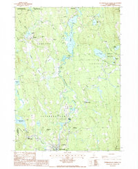
1987 Map of Peterborough North
USGS Topo · Published 1987About this map
Peterborough and its neighboring villages are captured here in the late 1980s, revealing a landscape defined by the winding course of the Contoocook River. The map highlights the famous MacDowell Colony, a renowned artist residency, alongside local landmarks like the St Joseph Minor Seminary and the small residential clusters of North Village and West Peterborough. The industrial and natural history of the region is evident in the development around Powder Mill Pond and the MacDowell Reservoir, which managed the waterways that once powered local mills.
Find a feature on this map
42 named features on this map. Tap any name to fly to it.
Don’t see what you’re looking for? This feature index may not catch every label — zoom into the map to look around manually.
Map Details
Editions of this 1987 Peterborough North Map
This is the sole edition of this map. No revisions or reprints were ever made.
Other maps of this area

1898 · Monadnock
USGS Topo · 1:62,500

1900 · Peterboro
USGS Topo · 1:62,500

1926 · Hillsboro
USGS Topo · 1:62,500

1929 · Hillsboro
USGS Topo · 1:62,500

1930 · Lovewell Mountain
USGS Topo · 1:62,500

1936 · Monadnock
USGS Topo · 1:62,500

1942 · Keene
USGS Topo · 1:125,000

1942 · Lovewell Mountain
USGS Topo · 1:62,500

1943 · Fitchburg
USGS Topo · 1:125,000

1948 · Boston
USGS Topo · 1:250,000